Ikaros 1
Near-Space Balloon Mission
On Saturday, May 22, 2010, our team launched its first high-altitude balloon, equipped with a video camera, temperature and pressure sensors, and tracking equipment, from Carmel River State Beach south of Monterey, California. After a 1 hour 20 minute flight which reached more than 75,000 feet, our payload touched down 80 miles to the east on the western edge of the Central Valley. Below are links to some initial information, photos, video, and data.
- Press Release
- Photos on Flickr
- Video on YouTube
- Flight path in Google Earth
- Launch day Twitter feed
- Project details
- Bay School website
Flight Info
- Launch Date
- May 22, 2010 11:53am PDT
- Flight Duration
- 1 hour 22 minutes
- Ascent Time
- 51 minutes
- Descent Time
- 31 minutes
- Distance Traveled
- 129 km (80 miles)
- Maximum Wind Speed
- 278 km/hr (173 mph)
- Maximum Ascent Rate
- 8.5 m/s (1670 ft/min)
- Maximum Descent Rate
- 26 m/s (58 mph)
- Impact Speed
- 5.8 m/s (13 mph)
- Maximum Altitude
- 23,086 m (75,774 ft)
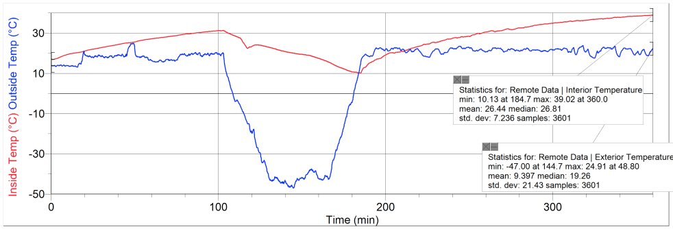
- Lowest Temperature
- -47°C -52°F
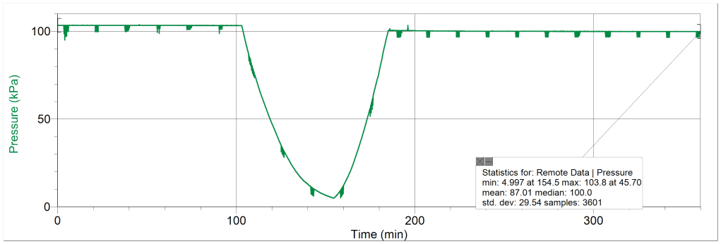
- Lowest Pressure
- 50 hPa (.05 atmospheres)
- Furthest Radio Contact
- 237 miles
Team Members
- Design and Flight Crew
- Robin Cassatt-Johnstone
- Sam Green
- Jesse Greenfield
- Meyer Jacobs
- Greg Karp-Neufeld
- Lucas Peck
- Engineers
- Willie Caldwell
- Ben Gershbein
- Ian Matthews
- Tom Mitchel
- Daniel Stuff
- Noah Tuchow
- Project Managers
- Craig Butz (cbutz@nullbayschoolsf.org)
- Richard Piccioni
Links we found useful
Project Details
- Balloon
- Helium and inflation
- Parachute
- Data collection
- Video
- Power
- Tracking systems
- Enclosure
- Launch site
- Flight
Balloon
We used a military surplus weather balloon.
Helium and balloon inflation
Because our tubing was quite small, inflation was very slow--taking nearly two hours. We also intentionally overinflated the balloon to make it rise faster in the high predicted winds. As the surface winds picked up, it became quite unwieldy. The balloon was inflated from the top and upsidedown, with the skirt draping to one side. This caused the balloon to inflate unevenly. Removing the skirt should reduce this problem and reduce weight.
Parachute
For recovering the payload, we decided to use a parachute with a 5ft diameter. The parachute used was originally intended for dropping supplies and other small payloads to troops. We purchased the parachute online from an army surplus store, and because it was a surplus item it was relatively cheap. Though we determined a 5ft diameter parachute was more than sufficient for safe recovery of our payload, the price of the parachute allowed us to buy it, and later modify it to obtain the optimal descending speed. When the parachute arrived, the first thing we noticed was that it weighed a lot. This was problem because we needed to keep the weight low so that we could use less helium and achieve a higher flight ceiling. In order to shave off some weight, we re-rigged the parachute with thin 50lb test strength fishing line and got rid of the heavy thick nylon cordage that was originally used. After figuring in the total mass of the payload, we determined that the best descending speed would be around 10 mph, in order to make sure the payload didn't drift to far. Because the original parachute had a 5ft diameter, we found that it would slow down the payload too much; therefore it would travel too far in the high winds predicted on launch day. The morning of the launch, the parachute was cut down to achieve a faster descending speed. Though cutting down the parachute wasn't ideal, it ended up working well. The parachute completed its task of safely recovering the payload at 13 mph/6 m/s.
-Willie Caldwell
Data collection
For our mission's data collection we primarily used the program Vernier Logger Pro, the portable LabPro apparatus (277g without batteries), and Vernier temperature(54g) and pressure probes (88g). We first had to decide which probes to send to space. We initially wanted to send many different types of probes, but we settled on only including 2 temperature probes (one for inside the box one for outside) and a gas pressure sensor. We tested the Labpro and the probes at various temperatures and pressures using a vacuum chamber. Finally, we found the maximum amount of time the LabPro could collect for, and increased it by decreasing the frequency of each data collection point. The instructions for launch day were as follows:
- Connect it to your computer with the USB connector (REMEMBER TO BRING THE CONNECTOR).
- open Logger Pro, go to "Experiment" "Data collection," and select how long you wish to collect for (the LabPro may have a limit of how long it can collect)
- Click "Experiment" "Remote" "Setup" "LabPro 1"
- Press OK and disconnect the Lab pro when it tells you to
- press the "Start/Stop" button on the labpro to start data collection. Press it again to stop collecting
- Replug the LabPro to your computer via the connector. A box will come up in Logger Pro asking if you would like to retrieve the data. Press "Yes" or "Cancel" (DO NOT PRESS NOW. IT WILL DELETE ALL THE DATA ON THE LABPRO!!!!) Import data to current session in logger pro, don't worry if your computer freezes up a little.
When we recovered our LabPro's data, it yielded similar result to those we hypothesized. The interior temperature stayed relatively constant, ranging from 31.5°C to 10.5°C in flight, while the exterior temperature decreased significantly at higher altitudes, ranging from 24.9°C to -47°C. However, we did not expect the interior temperature to decrease as the payload fell. The internal temperature stayed warmer than we expected. An important question to answer is whether that was more a result of insulation or heating by the electronics.
Noteworthy is that the temperature leveled off and even went up a few degrees when the pressure was at its lowest, indicating that we truly made it well into the stratosphere.
Similarly the pressure data was relatively predictable due to the lower pressure in the stratosphere. As our payload's altitude increased the pressure decreased very significantly, ranging from 103.8kPa to 4.99kPa. Based on our data, we can see that the balloon popped around 154 minutes (2hrs 34min) after starting collection, 52 minutes after launch.
-Noah Tuchow
Video
The video camera was a
Power
Most components had supplemental power provided by AA Energizer Ultimate Lithium batteries, which are very light-weight, long-lasting, and work at very low temperatures.
Tracking
For our balloon we had 3 different tracking systems. These include: APRS, a cellphone, and a device called LOCi.
GPS/APRS
Our main tracking system was the APRS. APRS stands for Automated Packet Reporting System. The idea behind the APRS is that it sends data, from a GPS device, through radio waves. These radio waves are transmitted on amateur or "ham" radio frequencies. The people who receive these signals from their ham radios then broadcast the signal to the Internet where the location is shown. Some of these sites include: openaprs.net and aprs.fi. Note: For the APRS you will need someone with a valid ham radio license and a ham radio callsign.
One of the first steps to building an APRS tracking system is to build or buy an antenna. Without the antenna, the APRS will not be able to transmit. To get widespread coverage we constructed a quarter-wave ground plane antenna. Rather than bending the radial elements down, we kept them horizontal and inverted the antenna to hang under the payload in hopes that it would aim the transmissions out in all directions, but below the horizon. You will also need to calculate how long each antenna element is. For example our balloon was transmitting on a 144.39MHz so we needed to have about a 19 to 20 inch long elements, there are calculators on the internet that will calculate the length of the elements; all you need to do is put in the frequency that you will be transmitting at. The antenna should be facing the ground because you have to send the signals to the ground in order for others to receive the signal. Therefore we built protection for the antenna so the impact would not break it. (All the styrofoam you see below our payload is just to protect the antenna).
The 2nd part of building an APRS tracking system is buying a transmitter. We bought a transmitter from a company called Byonics. The specific transmitter we bought was the Micro-Trak 8000FA. The transmitter is what transfers the GPS data to radio waves and then sends this information to the antenna where it is broadcasted. This was our single most expensive item on the balloon so we wanted to protect it well. You will also need to program your settings into the Micro-Trak. There is a program that allows you to do so, on the Byonics site for free of charge. There is a manual for what every setting means.
The Microtrak was connected to an old Garmin eTrex Legend, which, unlike many GPS's, functions and correctly reports its altitude above 60,000 feet. For power, we connected a pack of 8 AA lithium batteries.
Once we were done we tested device. The way to test your device is to try and broadcast a signal. Then after you think you have transmitted go to an APRS website and see if you are on the map. This was very frustrating for us because it was not working the first few times we did this. Eventually we figured out that the GPS wasn't set to the right data format.
This system is great for tracking mid-flight. As long as you have an internet connection--we used an iPad--to access an APRS site you will be able to track the balloon. We programmed our transmissions to occur every 30 seconds at 5 watts. So every 30 seconds we would have a different altitude, horizontal speed, and bearing. The accuracy of these reports depends on how many satellites the GPS is using at the time. To even be able to receive a position report the GPS must have a strong signal on at least 3 satellites. We had a strong signal on at least 6 satellites and our APRS was extremely accurate. In fact when our balloon landed it was still transmitting its position because our protection on our antenna worked, and the landing coordinates it gave us were exactly accurate. This system may be hard to build and operate but it is well worth the effort as it will, if built and programmed correctly, give you in-flight data and if your protection for your antenna works it will lead you to the exact position of where it is.
-Jesse Greenfield
Motorola i290
Backup cellular tracking system which reported location information via the internet near the ground and briefly (with incorrect altitude data) at high altitude.
Enclosure
The payload enclosure consisted of a cardboard box containing layers of styrofoam with cutouts for the components (which generated some heat). Internal temperatures only fell to 50°F; at the coldest point, it was 130°F warmer inside the box than outside, so this setup worked well.
Launch site
Ikaros I was released from Carmel River State Beach, south of Monterey, California. Although flying over the coast range was risky, we chose this site based on the predicted high winds aloft, which we were afraid would blow the balloon into the Sierra Nevada.
Flight
Using an iPad for mobile internet, we were able to continuously track the location, speed, and altitude of the balloon throughout the flight as we drove to the central valley. It took a few hours to catch up with it in the foothills west of I-5.